

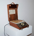
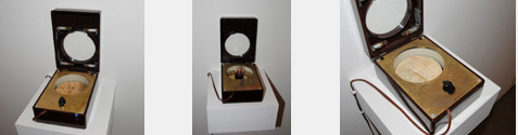
Model 47 Trinity Diorama
The Model 47 Trinity Diorama is a measurable analog of the Trinity Site and surrounding area, as it appeared shortly after 6 July 1945. As is well known, land may tell many stories; but in this case only two can be found embedded in the landscape-analog, using the attached probe. The analogy is reasonably accurate, as indicated on the legend; 1 mile absolute, ½ mile relative, no vertical scale. The history of this site was intentionally obscured or at least obfuscated; also, the physical terrain has in fact changed, especially since the configuration mapped here was a temporary one -- the results having been obtained, everyone went home (except rancher McDonald, ousted for the purpose), and one small mess being left in the military desert.
The instrument is built in the cabinet of what was called an "M2 Meter Tester", built by the Marion Electrical Instrument Co., Manchester New Hampshire, in 1956. The plaster model is measured and carved to fit a modern aerial contour map; the roadways and surface features were placed using a combination of modern and historical maps, historic photos and drawings, government maps and drawings, and a couple of personal site visits and photos. It is doubtful that this restored and composite information exists elsewhere.
The electronics are a hybrid of old and new; the electron tube amplifier visible in the back of the instrument is built upon the original Marion electronic assembly, stripped down to the tube sockets, amplifies the weak signal obtained from the probe and drives the loudspeaker on the front panel. Embedded within the device are additional, modern electronics that contains the two-channel sound source that drives two transducers in the desert soil.
The front panel is etched and corroded copper, enamel filled, and tin plated. The solid wood case has been shellacked and oiled; inside the removable cover are a legend to the numbered notable sites on the map, a set of spare tubes in a phenolic and copper box, and a clip to hold the probe.
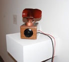
Model 17
The Model 17 is the second WPS product. Initially considered a failed project, it seems to have warmed with time's passing. It has a funerary feel to me; the cast stainless steel ear, lined with dog's hair, painted with Glyptal, faint ivy patterning in corroded copper and tin, emanates sounds at once organic and mechanical issuing from it's hairy ear/throat.
A single large, unmarked knob hopefully invites you to turn it, which tunes across a brief portion of a commercial/military short wave band. During daylight hours, essentially nothing will be heard but weak static. Bored, ignored and abandoned, when the sun goes down, affecting upper-atmospheric radio conditions, a disturbing mixture of radioteletype, weather station images, and international proselytizers blur into an auditory hallucination.
Within an old oak instrument box (a Hewlett-Packard Attenuator) is a small regenerative radio receiver. On the rear are controls for radio sensitivity, a combination volume/power switch, and the antenna jack. No real skill is needed to operate; the rear controls are adjusted for a compelling but not-too-loud sound. The provided antenna, a dozen feet of old-fashioned rubber test lead, can be simply tucked under a rug or along a wall. It consumes nearly no (5 watts) power.
The Model 17 is best left turned on and tucked into a corner; it will come alive at night, audible when passed by in a darkened room.
Encapsulated Landscapes
The Encapsulated Landscapes are part of an as-yet indeterminate series, each describing peculiar, little-seen and hidden-away uses of the earth. Built into new 1950 brown Bakelite instrument cases, each contains layers of information; the windowed cover tilts up to reveal an etched brass panel with inscription encircling the electro-phosphorescent-illuminated chamber holding the landscape. Dim, yellowed lamps inside the cover partially illuminate the brass panel, visible through the circular window.
WPS-LE1 is yet another way to look at the Trinity Site in New Mexico, cleaner than the tourist vision, with less detail to confuse. A green glow illuminates the terrain equally from all sides providing an apparently impartial view. The ringing in the ears leftover from the 1940's is still present, this time with a volume control for your convenience.
WPS-LE2 is of a place to the north and west of Las Vegas, Nevada; west of Saint George, Utah whose residents know not quite enough of, or maybe too much. Not a lunar landscape, and not craters really; these are subsidences, mere visible dips in the surface over a huge molten/crumbled rock bubble in the earth below, the whole thing a nice model of Cold War political/technological development: obscure results hidden from far-overhead enemy observers, allowing plausible-deniability to its citizens; the results of "testing" "devices".
WPS-LE3a is a reference to yet another place of damage and beauty, a ring of islands made by tiny water-bugs over millennia. More or less completely forgotten, except of course to those that were relocated before the utilization, these balmy islands have peculiar histories; one no longer exists, and another had a bathing suit named after it.
Encapsulated landscapes are best experienced mounted on a wall, in a dark room or hallway. When hung as a group, and it is extremely quiet, and you listen carefully, the singing/ringing boxes cause beat interference, audible as undulating low, sad tones.